Blog

Supermoon Eclipse time lapse

I met up with some people last night to watch the eclipse and brought my gear with me. It was a beautiful night for it. I thought it was going to be too cloudy, but the clouds went away right before it started and didn't come back until it was almost over. Clear skies for almost the whole thing!  I didn't set out to do a time lapse composite, but a friend on Facebook planted the seed, so I figured why not?

I used a Nikon D800, a 70-210mm f2.8 zoom lens, and a 2x teleconverter (for a total of 420mm). Because of the teleconverter, the widest I could open the lens was f5.6. Even with all that magnification I still couldn't come close to filling the frame. Ideally I would have had at least a 1000mm f2.8 lens. Here is one of the full moon shots in its original full frame.

Exposures were a little tricky because there is such a huge brightness difference between the fully lit moon and the eclipsed moon. With the lit moon I was shooting around ISO 2000, 1/1250 @ f27. I tried to keep my shutter speed fast to reduce camera shake and moon movement. As the moon became eclipsed however, I had to really change the exposure just to be able to see it. For the full eclipse I was shooting around ISO 6400, 1/50 @ f5.6. You can really see the difference in the seventh moon from the left in the composite. I wanted to start capturing the shadow side of the moon, but in doing so I had to blow out the thin crescent that was still lit.

I did try going above ISO 6400, but the image starts to get pretty noisy at that point, and the blacks start to wash out. Here is a cropped example to see how grainy it looks at those really high ISO speeds.


The composite image was simply done in Photoshop by dragging and dropping just the moon from each frame onto a larger canvas. I made slight adjustments to the density of each moon just to even them out a little, but other than that the color you see in the final composite is how the camera captured it. The arch of the composite is not the actual trajectory of the moon, that is my own simple design that I thought looked cool. The moon actually went almost straight up from the horizon. Clouds rolled back in before the eclipse had fully finished, so the full moon at the right end of the composite is a copy of the moon from the left end of the composite. I wanted to finish the sequence so I allowed myself that one cheat. Also, the composite does not proportionally represent the time duration of the eclipse. The center image of the fully eclipsed moon was the longest portion of the event, lasting over an hour.

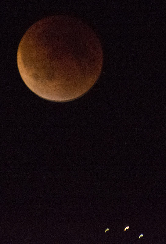
At one point I managed to capture an airplane passing near the moon. All you can see are the lights on the plane, not the body of the plane itself. Its the three lights at the bottom of the image below. Another time while readjusting the camera (which I constantly had to do as the moon moved across the sky) I was looking through the viewfinder and saw a shooting star! I wish I had captured that! Even if I was quicker I wouldn't have captured it since I was using the camera's self-timer set to 2 seconds to help reduce camera shake.

It was a fun and much needed night out of the house (I've been dealing with a cold the last few days and haven't gotten out much). I met some new people, drank some wine, took some pics, and witnessed a wonder of nature!


Mount Rogers, highpoint of Virginia. OH MY GOD!!! LOOK AT ALL THE FUZZY PONIES!!!

Mount Rogers, Virginia state highpoint. 2014.

Mount Rogers, Virginia state highpoint. 2014.

Summit Date: July 21, 2014

Mount Rogers is the high point of Virginia, and is located at the western end of the state. It was my first summit in the series of peaks known as the "Southern Six-pack". These are six state high points that are all relatively close to each other, They include the high points of Virginia, North Carolina, South Carolina, Georgia, Tennessee, and Kentucky. Mount Rogers is the only one of the six that requires an actual hike, with the rest being drive ups. While not a technical hike, it is a decent length, about 8 miles round-trip. A portion of the trail to the summit follows the famous Appalachian Trail. The lower sections of the trail are open, grassy pastures with large exposed outcrops of rock. As you get closer to the summit it becomes more densely wooded and less rocky.

But that's all the boring academic stuff. When people talk about Mount Rogers, one thing always comes up; wild ponies. While researching this trip I read that Grayson Highlands State Park (the park you have to hike through to get to the summit) is home to over 100 wild ponies. While an exciting prospect, I tried to keep my expectations of actually seeing any of them to a minimum as it is a large park and they are free to roam anywhere within it.I recalled my visit to Isle Royal National Park, an island in Lake Superior famous for its isolated wolf and moose populations. Three days on the island and I didn't see a single wolf or moose. With Mount Rogers I would've considered myself lucky just to get a distant glimpse of the ponies. And on the hike up to the summit that's all we got; distant glimpses. Just two or three times on the way up did we see little brown specks against the sea of green in the distance. After 4 miles and a couple of hours we made it all the way to the summit without a single wild pony encounter. Not once did we cross paths with any of them. While it was a beautiful hike and I did get the summit, I was really hoping to meet some of those wild ponies. On that front, it looked like this trip was going to be a bust.

But then we still had the hike down…

As we came out of the denser woods surrounding the summit we came upon a clearing. And there they were. Wild ponies! It was a group of around five individuals, a few dozen yards off the trail. We tried to approach very slowly and quietly so as not to startle them. I wanted to see how close we could get. We got closer. And closer. And closer. They didn't really seem too shy. One in particular was very friendly. He approached us, checking us out. At one point he started trying to eat my boot. So there we were finally getting to see the storied wild ponies of Mount Rogers. After hanging out with our new furry friends for a little while they slowly started to wander off, as did we. We continued on our way down the trail excited about our encounter with the local wildlife, grateful for that one chance to see them.

And then we ran into another group of them. And another. It was as if all the ponies knew they had missed us on the way up and were now making it up to us on the way down. I lost count of how many ponies we saw altogether. Several dozen at least. They were even hanging out right at the last fence before the final stretch back to the parking lot. I don't know why but they had suddenly come out in full force on the way down. And it wasn't just the ponies. We also came across a small group of cattle. One was a gigantic bull with huge horns. I was a little wary of him but he didn't seem to mind us at all. We eventually made it back to the car and continued on our way to our next stop,the tri-point of North Carolina, Tennessee, and Virginia. This would definitely go down as one of the highlights of my high pointing adventures.

Check out the gallery and video below to see the beautiful Mount Rogers and it's adorable wildlife.

A short video of my trip to Mount Rogers, the highpoint of Virginia, from July 21, 2014.

Shiri and I at the summit of Mount Rogers.

Shiri and I at the summit of Mount Rogers.


Tri-point of North Carolina, Tennessee, and Virginia. My car meets its match.

Tri-point of North arolina, Tennessee, and Virginia. 2014.

Tri-point of North arolina, Tennessee, and Virginia. 2014.

The first three posts in this series (Sassafras Mountain, Ebright Azimuth, and Charles Mound) were all looking at state highpoints that I have visited. Well, there's another type of point that I go to that not a lot of people think about: the tri-point. These are simply where the borders of three states come together. Everyone is familiar with the four corners in the American Southwest which comprise the states of Arizona, New Mexico, Colorado, and Utah. Four corners could be thought of as a bunch of overlapping tri-points. With the exception of Hawaii, all of the states have tri-points with other US states, Mexican states, or Canadian provinces.

This particular tri-point is deep in rural Appalachia, and not far from Mount Rogers, the highpoint of Virginia which we had just hiked earlier in the day. There wasn't much left of the day, but the descriptions I had of it showed there was a rugged dirt road leading right to it. I had taken my car (an all-wheel-drive Toyota RAV4) through some pretty gnarly spots so I wasn't too overly concerned about getting there. I got off the main road and through the village of Whitetop, Virginia, to where the dirt road started that led to the tri-point. It was a run-of-the-mill dirt road with houses and farms dotted along its winding path. (Side note: every road in Appalachia is winding.)

The directions I had mentioned a gate that I would be driving through and to ask permission to go any farther. I eventually did come to a gate (which was open) and stopped at the residence nearby to inquire about the tri-point. This is where I knew I wasn't in Kansas anymore. As I rolled down the driveway of the rundown looking property, I saw two men working on a piece of farm equipment. I got out of the car and approached the two men (I left the car running just in case). Both men were covered in grease and looked like they hadn't showered in… a while. The older of the two men had a beard and not much in the way of teeth and did all of the talking. The other man, who did not look quite as old but still had white hair, stood silently to the side. His greasy arms hung at a slight angle away from his sides. He just looked at me with a blank expression through his thick horn-rimmed glasses and never uttered a word. I asked about the tri-point and it took a few tries to communicate what I was talking about. It was hard to understand what the man was saying. This went beyond the quaint Appalachian drawl that everybody is familiar with. This felt more akin to being in a foreign country and trying to communicate across a language barrier with one of the locals. I finally learned that I was about 3 miles from the tri-point. I'm surprised I didn't start hearing banjos.

I continued up the dirt road for about two more miles. That's when the condition of the dirt road started to rapidly deteriorate. The ruts became worse. I was in low gear moving at a crawl. I could not simply drive straight down the road. I had to weave from side to side following the contour of the ruts in an effort to not bottom out. I was doing well until, while trying to cross one of the ruts, I felt my car bottom out and my engine became tremendously loud. I knew right then that I had damaged my exhaust, most likely hitting one of the pipes coming off the manifold on a rock. I just sat there in dread for a few minutes hoping it wasn't as bad as I thought. Worst-case scenario was that I had sheared the manifold right off the engine block. I decided to try and continue on, and as I tried passing over the same rut I started spinning out. That was it. I wasn't going any farther in the car. In the following picture you can see where I left the car. Just off the passenger side you can see two dark patches in the dirt. This is where I spun out as I tried to cross the rut. The picture doesn't do justice to just how bad the road actually was. To go any farther I would've needed a proper off-road vehicle, such as a Jeep Wrangler or a Toyota FJ Cruiser.

My car on the way to the tri-point. This is as far as she got.

My car on the way to the tri-point. This is as far as she got.

Now I had to decide whether or not I should continue on at all. It would mean going on foot, but I didn't know exactly how close I was (or how far). I didn't have a good enough cell signal to really use the GPS on my phone. What did work, however, was that the map app on my phone was still registering my current location. I could see the dotted lines indicating the state borders and the dot indicating my current position, and that was it. I tried switching over to satellite view, which would've helped for figuring out landmarks, but I simply didn't have enough signal for it to work. If the standard map view was reading right, then I would be able to tell how far I was by how fast my dot was moving in relation to the borderlines. I decided to continue on foot. As the sun was getting close to setting, I really wanted to hustle to get to the tri-point. Shiri was with me but she said to go on ahead so I could start taking my pictures and she would catch up. I loaded up my gear and headed off. I kept a close eye on my cell phone and studied my movement as I made my way down the road. My dot was moving quite briskly so I knew I wasn't too far. I also noticed that the road got even worse as I went along, with the ruts becoming quite deep. As it turns out I was probably less than a half-mile from the tri-point.

A short clip of me from the tri-point of North Carolina, Tennessee, and Virginia.

After successfully getting to the tri-point and taking my pictures, we made our way back to the car and started back toward town. The closest city to stop and get repairs was Bristol, Tennessee. The city is famous for its NASCAR racetrack, so I knew there would be somewhere there that could take care of my car. However, there would be one last piece to the adventure before we would get there. As we rolled through the village of Damascus, Virginia, I saw a cop car and had a gut feeling they were going to notice me. Keep in mind I basically had no exhaust and my car sounded like a jet engine. Sure enough, it pulled out behind us and a few blocks later put on its flashing lights. The officer was actually pretty cool about it. I explained what happened to the car and that I was on my way to Bristol to get it fixed. He didn't give me a ticket and even gave me something saying that I had been pulled over for it once just in case I got pulled over again between there and Bristol.

After spending the night at a hotel in Bristol, the next morning I took it right to a Toyota dealership to get it fixed. After getting there early so I could be first in line and waiting for about an hour they told me that they would not be able the fix it without special ordering a part which would take a day or two to arrive. Spending a day or two in Bristol would have totally thrown my plans for the whole middle of the week out the window. The guy gave me some hope though by telling me that another garage that they work with often that does custom welding might be able to help. I took it there and within an hour they were able to fix it. And it only cost about $80. With my car once again purring like a kitten we hit the road again and headed for our next destination which would be Mount Mitchell, the high point of North Carolina.

Also of note was the discovery that Christmas trees are a major regional crop in the area. Starting soon after we left's Mount Rogers, we started to notice the fields of Christmas trees. Around where I live in central New York you'll see the occasional Christmas tree farm. So it wasn't that the site of a field of Christmas trees was strange, it was more the sheer scale of it. This was a major crop in this part of the country, Much like how you'd see cornfields driving through Iowa. It was just one of those funny things; you don't think of Christmas trees as being a crop, but there they were, field after field of them.

Standing on the tri-point of North Carolina, Tennessee, and Virginia.

Standing on the tri-point of North Carolina, Tennessee, and Virginia.


Charles Mound, Highpoint of Illinois. A farmland stroll.

Charles Mound, Illinois state highpoint. 2014

Charles Mound, Illinois state highpoint. 2014

Summit Date: September 7, 2014

Most of the 50 state highpoints are located in parks of some kind, whether it be local, state, or federal. This makes them open to the public. Charles Mounds, however, is one of the few highpoints that are located on private property. While physically very easy to get (a gentle one-mile stroll up a dirt road) in terms of access it is one of the trickier high points to get to. The property owners are nice enough to allow highpointers on the first full weekend of the four summer months. However, this means that the highpoint is only accessible to the public for eight days a year. I planned my visit for the last open access day of 2014, Sunday, September 7.

I flew from Syracuse to Chicago the night before and then drove a rental car from Chicago to Scales Mound, which is only about a mile from the trailhead. I slept in the parking lot of the town park. I've gotten used to car camping with my RAV4, which I built a bed for and is actually quite comfortable. So when I decided to crash in my car for the night I didn't think much of it. Well, my small rental sedan was definitely not made for car camping. My 6 foot frame trying to fit in the back seat just didn't really work. Not to mention it got cold. I had only packed a small backpack and wasn't expecting it to get cold overnight. The next morning however, once the sun came up it was quite pleasant.

I arrived at the trailhead just before sunrise. I use the word "trailhead" loosely, as the trail is actually a dirt farm road leading from the street up to the private residence and the highpoint. Even though the trail was only a little over a mile long with not much elevation gain, it still felt like the environment changed a few times on the way up. The first part is a long flat stretch with a cornfield on one side and a wooded gully on the other. Once the trail starts to go uphill it becomes wooded on both sides. Eventually the woods give way to large bean fields. On the far side of these fields are a few barns and a little pond. Then it becomes wooded again for the rest of the way up to the highpoint. Once at the summit there are views to the north of more fields and rolling hills.

The whole experience was very peaceful. The skies were clear and there was no wind, no traffic, no hordes of tourists. I had the summit all to myself while I was up there. On the way back down I ran into some fellow highpointers and traded stories with them. One of them was a retiree who, in his younger days, had worked for the National Park Service and actually lived in Fort Jefferson, located in Dry Tortugas National Park, Florida. I also ran into another highpointer who was visiting from the UK. I'm glad I was able to make it for one of the open access weekends. This also marked my 20th High Point.

Trailhead for Charles Mound.

Trailhead for Charles Mound.

The summit path through a section of woods.

The summit path through a section of woods.

The sunrise over a field of soybeans.

The sunrise over a field of soybeans.

Looking back toward the town of Scales Mound.

Looking back toward the town of Scales Mound.

The view to the north of the summit.

The view to the north of the summit.

Me with the summit sign.

Me with the summit sign.


Ebright Azimuth, Highpoint of Delaware. Rock bands and space shuttles.

Summit Dates: September 3, 2004, May 17, 2010, December 7, 2013, January 1, 2018

Of the 27 highpoints that I have visited, Ebright Azimuth is by far the easiest one to get. While many of the others aren't exactly difficult, with this one you can literally stop your car, open the door, step out, and be at the summit (although the precise location of the summit is still somewhat in dispute). It's at an intersection in a suburban neighborhood at the northern tip of Delaware. It's so easy in fact that I have visited it four times. Usually when I visit a high point, I have made special plans to visit it and the whole trip is centered around it. With Delaware however, all four visits to the highpoint were the result of simply passing close by on my way to somewhere else and figuring I would stop by since I was in the area.

My first visit to Ebright Azimuth came on September 3, 2004. My friend Brooke and I were on our way to Atlantic City, New Jersey to go see my favorite band Van Halen perform live in concert. The high point was not far off the route to AC. Unlike today when you can just put in the location in your GPS, at the time GPS was not widespread so I just relied on instructions I found online on how to get there. It's well marked so it's not that difficult. When we were there we were approached by a woman who lived around the corner. She appeared to be the unofficial welcoming party for the high point. She told us a few tidbits about the high point and even gave us a little brochure about it.


Brooke and I with the summit sign. 1st visit, 2004.

Brooke and I with the summit sign. 1st visit, 2004.

Unfortunately, the panorama that I shot on that visit is essentially unusable. Despite it being a beautiful day for shooting, my technique at the time was not as good as it is now. I was still shooting on film and my exposures were all over the place. I was using the auto aperture setting on my camera which made each exposure slightly different and resulted in a panorama that would've taken much more work than I wanted to put into it. I now know, of course, to keep the exposure consistent for the entire set of images for best results. It would be six years before I would have the opportunity to reshoot it.

To the right is a picture of Brooke and I with the summit sign. At the time it was located across the street from where it is now. In the panoramas below it would have been by the bushes on the corner near the left end of the image.

Ebright Azimuth, Highpoint of Delaware, 2nd visit, 2010.

Ebright Azimuth, Highpoint of Delaware, 2nd visit, 2010.

Launch of Atlantis on May 14, 2010.

Launch of Atlantis on May 14, 2010.

My second visit was on May 17, 2010 when I was on my way back from a trip to Florida to see the next to last launch of the space shuttle Atlantis at the Kennedy Space Center. Seeing the launch was one of the coolest things I've ever witnessed in my life, and I'm so glad I had the opportunity to see it. I was positioned about 7 miles from the launch pad and I couldn't have asked for a better day. It wasn't too hot, there was a gentle ocean breeze, and not a cloud in the sky. I shot the image on the right with my 210 mm lens, and even then I had to crop out about 80% of the image to get this composition because I was so far away from it.

The only bad part about this trip was the night before the launch I was bitten by about five fire ants. I had encountered these little bastards when I lived in Texas and they're not fun. They bit me on my right foot which swelled up to the point where I drove myself to the emergency room after the launch.  They put me on a steroid regimen for the swelling and by the time I reached the Delaware highpoint a few days later the swelling had come down considerably.

At the high point I was finally able to rectify my mistakes from six years earlier and capture some decent exposures to make a nice, clean panoramic image. The resulting panorama from my second visit is also the only one that I've made so far which incorporates a selfie. I don't normally do it, but it just seemed to work for this one.

Ebright Azimuth, Highpoint of Delaware, 3rd visit, 2013.

Ebright Azimuth, Highpoint of Delaware, 3rd visit, 2013.

My third and final visit to Ebright Azimuth was in the wee hours of December 7, 2013. Just like the previous two visits, this one occurred as the result of going to a separate event and this just happened to be on the way. My girlfriend Shiri and I are fans of the band Sponge (who saw the height of their national popularity during the mid-90s). She has seen them so many times that she's actually friends with the guys in the band. They were doing an East Coast tour and we were driving from Shiri's home in Brooklyn to the bands gig in Baltimore, Maryland. The high point was just a few miles out of the way.

I normally don't plan too much as far as trying to be at a highpoint during a specific time of day. Usually I have a small window of time to be at a highpoint and get my images, either because my travel itinerary doesn't quite have the flexibility to hang around all day or because the nature of a hike dictates what time of day you get to a highpoint.

Shiri being serenaded by Vin from sponge in Baltimore, Maryland.

Shiri being serenaded by Vin from sponge in Baltimore, Maryland.

Shiri with the summit sign. Her first highpoint!

Shiri with the summit sign. Her first highpoint!

With this one I wanted to try something a little different. I had never tried a nighttime panorama from a highpoint and this was a good opportunity to do it. I opted to wait until after the Sponge concert and make the visit on the drive back to Brooklyn. This way I wouldn't feel rushed thinking I had to hurry up and finish so we could get to the show. Sponge shows usually go till after midnight and then we hang out with them afterwards, so by the time we got to the highpoint it was almost 3:00 in the morning. Being early December I had several hours before the sun would come up so I knew I had time as far as that went. However, being early December also meant that it was cold, and on this particular night it was also raining which made it feel extra cold. I set up in the exact same spot that I had on my second visit and started shooting. Shiri was there to hold the umbrella over me while I shot to keep me in my gear somewhat dry. I needed my bare hands to operate the controls on the camera and as a result my hands got so cold that by the time we got back to the car they actually hurt quite a bit. I had to just sit and let them warm up a little before I could even drive. But I got the shot!

UPDATE:

Added my fourth summit of Ebright on New Year's Day of 2017. And in keeping with tradition, I only stopped because I was on my way back from something else. The day before, my friend Brooke (who was with me on my '04 summit) and I went to Baltimore to see comedian John Oliver perform. On the way back Brooke wanted to stop at the Baltimore Ikea. It was far enough off our original route we took down that Google maps suggested a different route on the way home. A route that took us right by Ebright Azimuth. So of course I had to pop in for a visit. It was pretty cold out, so we were there just long enough to take some selfies and we were on the road again. To date it's only my second winter highpoint. The other being Mount Greylock in Massachusetts.

New Year's Day on Ebright Azimuth. I wonder if I was the first highpoint of the year?

New Year's Day on Ebright Azimuth. I wonder if I was the first highpoint of the year?


Sassafras Mountain, Highpoint of South Carolina. Please excuse the mess.

This is the first in what will be a regular series of blog posts about my highpoint/tri-point panorama photography. Each post will give a little background and behind the scenes look at one photo. I've started shooting video in recent years, so I'll try to include it whenever possible along with other photos of the area.

First up:

Sassafras Mountain, South Carolina. 2014.

Sassafras Mountain, South Carolina. 2014.

Summit Date: July 22, 2014

This image of Sassafras Mountain is probably one of the best examples of my philosophy about my highpoint/tri-point photo series; whatever it looks like at these locations, that's what I shoot. Many times the locations I visit are very scenic and picturesque, which is great, but my goal is not to take pretty pictures. My goal is to capture these places however they happen to look. In this case, it happens to involve fallen trees and construction equipment. The summit of the mountain is being converted into a visitors center, not unlike its southern highpoint neighbors North Carolina, Georgia, and Tennessee. I just happened to visit during that awkward transition stage after its more natural state and before the development is finished.

My camera for this image was placed right next to the USGS marker. A giant rock with a metal plaque on it about the summit had been moved to the far side of the green tractor on the left of the image. The summit was officially closed to visitors because of the construction, but was easy enough to access. There were no other visitors so I made a run for it! And just so you don't think that the entire area looked like a clear-cut forest, just below the summit was a lookout platform with views of Georgia and Tennessee to the west. It was late in the day and the sun was going down, which made for a really gorgeous view.

View to the west of Sassafras Mountain.

View to the west of Sassafras Mountain.

Standing with the summit marker surrounded by fallen trees and construction equipment.

Standing with the summit marker surrounded by fallen trees and construction equipment.

Rock with marker plaque.

Rock with marker plaque.


I also shot a short video while I was on the summit. I apologize for the shakiness! 


Maine 2013 roadtrip video journal finished!

This has been a back burner project since last summer. I've finally finished editing my video journal from last year's trip to Maine for the highpointers convention. It takes place over the span of a week and chronicles my visits to Massachusetts, Vermont, New Hampshire, Quebec, New Brunswick, and Maine. I shot all the footage with an iPhone 4S and a GoPro Hero3 Black. It was edited using iMovie. About 9 of the images in my portfolio were shot on this trip and the locations and finished images are featured in the video. Enjoy!


New Work! Katahdin & Carleton

I've been inactive on the photo front for a little bit. Life and stuff. Well this past weekend I did some catching up. I FINALLY finished the panorama stitch of Mt Carleton (highpoint of New Brunswick). This pano has been mocking me for months. As usual, having the sun in the image is problematic. After several failed attempts at the composition I wanted, I tried it a different way and somehow, it just fell into place (still not easy, but I got it to work). I also put together a another pano from scratch (Mt Katahdin from Pamola Peak) and worked on my latest travel log video which will hopefully be done sooner rather than later. A very productive weekend!

Mt Carleton

Mt Carleton

Mt Katahdin from Pamola Peak

Mt Katahdin from Pamola Peak


First real field test of new camera; panoramas and concerts

A few months ago I purchased a new Nikon D800 and this past week I was finally able to really put it to the test, especially it's low light capability. Recently I caught four dates of the Sponge/Spacehog tour. I have always enjoyed shooting concerts, but they often have the issue of not being very brightly lit. With my old D200 I could never set the ISO much higher than 640, 800 tops, before the image quality really fell apart. It helped when I got a couple f2.8 lenes. Even then I was shooting at a 1/60 sec or slower, which resulted in a lot of motion blur. 

With the D800, however, not only am I passing the ISO 800 mark, but am shooing at speeds of ISO 4000! The image does get just a little grainy at these high speeds, but is still more than useable. Plus, I now get to shoot at faster shutter speeds to capture the action of the musicians playing and running around stage.

On the way to these shows, I was also able to stop at a tri-point and state high point for my ongoing series Unlikely Landscapes. One site was shot during dusk and another at night, and both were shot in light rain and frigid cold (this was the first time I had shot a high point at night). The D800 came through again, I was able to get decent exposures in poor lighting conditions with no problem. I've been blown away by the low-light capabilities of the D800, which was the selling point for me rather than the 36 megapixel rating.

I'm still using DX lenses, however, which means I'm getting a cropped image (15MP instead of 36MP). Considering though that my D200 was only 10MP I'm still getting a larger image and the same lens coverage. I'll get proper FX lenses for it one day, but for now, for my purposes, my f/2.8 DX lenses are d 

Check out below for the results of the images of Ebright Azimuth at night (the high point of Delaware) and the tri-point of Delaware, Maryland, and Pennsylvania. For the concert images, go to my Facebook page (link below).

Tri-state point of Delaware, Maryland, and Pennsylvania. 2013.

Tri-state point of Delaware, Maryland, and Pennsylvania. 2013.

Ebright Azimuth, Delaware state highpoint. 2013.

Ebright Azimuth, Delaware state highpoint. 2013.

Building a sleeping platform in my 2001 RAV4

I shot this video earlier this year before my trip to the Ohio and Indiana high points, but just recently was able to finally edit it together. It's the process of making the platform in my car for sleeping on an storing things under. I later used it when I attended the high pointers convention in Maine and slept on it for the first half of the week. It works like a champ and I can't wait to use it again!


Our border with Canada

Here is a short video about the border with our neighbor to the north, Canada. Pretty interesting. It talks about some of the irregularities in what looks like a really straight border. In July on my way to the Highpointers convention, I photographed three of the tri-points that lie along the border with New England. The tri-points of New Hampshire, Quebec, and Vermont and Maine, New Hampshire, and Quebec is on what I believe is called the "Slash". A fifty foot wide no man's land where all the trees have been cut down that runs the entire length of the border from east to west. I'm sure I'll be running into the slash again as I still have over a dozen tri-points on the border to visit.


Thilde Jensen book

Just got my copy of the new Thilde Jensen book "Canaries". Thanks Thilde!! The book deals with the sub-culture of people living with multiple chemical sensitivity. Definitely check it out if you get a chance.

2012 roadtrip

Here is the video for my roadtrip last year to visit and photograph a few geo-extremes in southern New York and New England It's about 26 minutes long.


This is a travel diary of my trip in the fall of 2012 to photograph several geo-extremes in New York and Southern New England; the southern and eastern most points of New York, the highpoint of Rhode Island, the tri-point of Connecticut, Massachusetts, and Rhode Island, along with places in between.

Welcome to my new website!

I'm very excited to finally have my own website! It's been a long time coming! I've had other webpages here and there, but this is my first one that looks and feels a true artists website, slick and professional.  


Check back to the blog often, as I plan on posting a lot of behind the scenes videos from my highpoint/tri-point trips from the past year, along with whatever else comes to mind.